Trail Walking Le Lorrain - Boucle Morne Ceron 01 - Photo

Boucle Morne Ceron 01

 Lamartiniere
Lamartiniere

User GUIDE

© OpenStreetMap contributors
Length
Length
15.4 km
Max alt
Max alt
445 m
Uphill gradient
Uphill gradient
629 m
Km-Effort
Km-Effort  
24 km
Min alt
Min alt
28 m
Downhill gradient
Downhill gradient
629 m
Boucle
Boucle
Yes
Creation date :
2017-06-28 00:00:00.0
Updated on :
2017-06-28 00:00:00.0

(1 Reviews)

Walking
Walking
4h11
Difficulty : Medium

Scan this QR Code to open this trail in the SityTrail application

FREE GPS app for hiking

Logo SityTrail SityTrail

IGN / Geographical institutes

Download SityTrail from the App Store Download SityTrail from Google Play

Logo SityTrail SityTrail World

The world is yours!

Download SityTrail from the App Store Download SityTrail from Google Play Download SityTrail on Huawei AppGallery

About

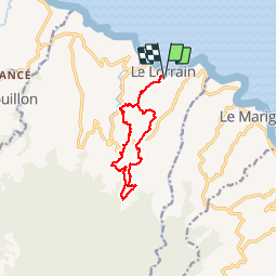
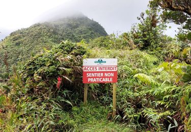
Trail Walking of 15.4 km to be discovered at Martinique, Unknown, Le Lorrain. This trail is proposed by Lamartiniere.

Description

Les Mornes Ceron, Landau, Icaque, Moreau, Octave, Gustave, Cledelin, Haut-Carabin, Etoile, Vallon, Ceron

Elevation profile

Photos

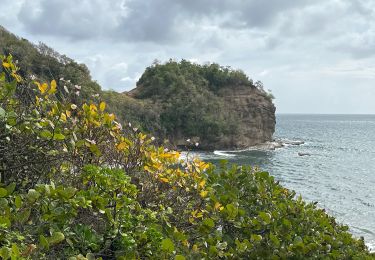
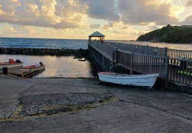
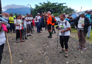
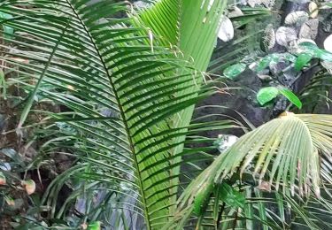
24 photos in total. Please click on a photo to see them all in the gallery.

Points of interest

Point of interest Le Lorrain - depart cheneaux le lorrain - Photo
Lamartiniere
Point of interest Le Lorrain - morne ceron - Photo
Lamartiniere
LE LORRAIN 
Point of interest Le Lorrain - Point 11 - Photo
Lamartiniere
LE LORRAIN 
Point of interest Le Lorrain - Point 22 - Photo
Lamartiniere
LE LORRAIN 

Positioning

Country:
France
Region :
Martinique
Department/Province :
Unknown
Municipality :
Le Lorrain
Location:
Unknown
Start:(UTM)
709328 ; 1640468 (20P) N.

Comments

Please log in to post a review or rate the element


Rando sur reliefs varies, bonne marche


Trails nearby

Trail sport Le Marigot - Reco partielle défi 24 - Photo
sport
GUIDE
manuelPerez

sport

Very easy
Le Marigot, Martinique, Unknown, France
5.5 km | 7.4 km-effort
Unknown
No
Trail Walking Le Marigot - Boucle Le Mariigot - Charpentier - SLNA. - Photo
Walking
GUIDE
Lamartiniere

Walking

Medium
(1)
Le Marigot, Martinique, Unknown, France
8.7 km | 12.8 km-effort
3h 0min
Yes
Trail Walking Le Marigot - Reco Rando Marigot  - Photo
Walking
GUIDE
manuelPerez

Walking

Le Marigot, Martinique, Unknown, France
7.1 km | 10.3 km-effort
3h 6min
Yes
Trail Walking Le Lorrain - Fond capot oceanic fond cani morne Degras - Photo
Walking
GUIDE
manuelPerez

Walking

Le Lorrain, Martinique, Unknown, France
8.5 km | 11.9 km-effort
3h 44min
Yes
Trail Walking Le Lorrain - Mornes Capot / Lorrain Martinique - Photo
Walking
GUIDE
GabyG

Walking

Medium
(1)
Le Lorrain, Martinique, Unknown, France
8.5 km | 11.8 km-effort
3h 41min
Yes
Trail Walking Basse-Pointe - Boucle de chalvet, Pécoule vers Chalvet. - Photo
Walking
GUIDE
GabyG

Walking

Medium
Basse-Pointe, Martinique, Unknown, France
6.5 km | 7.8 km-effort
3h 2min
Yes
Trail Walking Le Marigot - Marigot vers le Lorrain - Photo
Walking
GUIDE
GabyG

Walking

Medium
Le Marigot, Martinique, Unknown, France
4.8 km | 6.5 km-effort
2h 1min
No
Trail Walking Le Lorrain - Boucle Seguineau 22 Mai - Photo
Walking
GUIDE
Lamartiniere

Walking

Very difficult
Le Lorrain, Martinique, Unknown, France
14.2 km | 19.2 km-effort
4h 0min
Yes
Trail Walking Le Lorrain - Morne Jacob au Panneau ONF - Photo
Walking
GUIDE
Lamartiniere

Walking

Medium
Le Lorrain, Martinique, Unknown, France
4.3 km | 8.7 km-effort
2h 0min
No


Close
My subscriptions